Monday, 16 February 2015

Seismic reflection: imaging the upper crust


Over the last few days, we have been acquiring data in long transects from the young crust at the Costa Rica Rift, to older crust (up to 6 million years old) further from the spreading ridge. Since our OBSs for this stage still remain on the seafloor, we have predominantly been looking at our multichannel-streamer (MCS) data coming in. We mostly look at the reflections from this data, to study the upper structure of the oceanic crust.

A diagram of our MCS set-up. The source and receivers are towed behind the ship. Energy travels as waves down to the seabed and reflects back to be recorded by the hydrophones in the streamer.
Seismic reflection works by creating an acoustic (sound) pulse, which travels down to, and through the seabed, reflecting off boundaries as it goes. This reflected energy comes back to the surface and is recorded by our receivers in our streamer (currently 4.5 km long!). 

The data outputs in the form of time (from when the pulse was fired) against the amplitude of the sound wave recorded by our receivers. From this we can identify different waves of energy reaching the streamer: from the direct wave that travels straight through the water, to the seabed reflections and sub-seabed reflections.
Data recorded from a single acoustic pulse from the source. This shows the amplitude of waves recorded by the receivers, with receiver number along the streamer across the top (0-360), representing distance (0-4.5 km). Two-way travel time (TWTT) is down the side, called such as it represents the time for the energy to travel down through the water, reflect off a boundary, and travel back to the sea surface again. This can roughly be interpreted as depth if we have an idea of the speed which the waves are travelling at (~1500 m/s in sea water).

After some rough processing, we combine a large section of data to form a picture of the structure of the seafloor and crust, with horizontal distance against time, which can be roughly converted to depth.

So far we have found lots of interesting structures from our reflection data, including rough topography characteristic of mid-ocean ridges, faulting (fracturing) of the crust, and stratified sediment layers on the older parts of the crust. 
A roughly-processing seismic reflection image of a fault zone, with TWTT representing depth down the side, and CMP number (each CMP is 25m apart) representing horizontal distance across the top. You can see the rough topography with large ridges and valleys characteristic of these fracture zones, plus the thick layered sediment, showing that this is fairly old crust.

In other news, the first Science Café of JC114 was held a few days ago, with four short presentations to scientists and crew alike about the general purpose of OSCAR, and some of the exciting recent findings. Hopefully another will follow before the end of the cruise! We've also managed to lose the flock of red-footed boobies that were covering the A-frame just a few days ago. The chance of receiving some 'good luck' from above will not be sorely missed.
A few red-footed boobies perching on the met platform in the early morning


Thursday, 12 February 2015

Ship jargon buster


Seafarers have long been associated with language deemed peculiar and confusing by us ‘landlubbers’. Stereotypical phrases such as ‘ahoy there me hearties’, ‘scrub the deck’ and ‘shiver me timbers’ are these days mostly confined to Johnny Depp stumbling around a film set or old tales of Blackbeard, but modern seafarers still use vocabulary far removed from our everyday language. So called ‘Jackspeak’ covers normal things and places, as well as nautical-specific terms, and when at sea you’ll still be laughed at if you refer to your cabin as your bedroom.

Generic ship terms are of course commonplace: left and right become port and starboard, front and back become forward (where the bow is) and aft (the stern of the ship). The word ‘starboard’ is derived from the old word for a rudder, ‘steer board’, which would usually be placed on the right side of the ship, and to avoid crushing this against the dock the ship’s left side would be against the port.
The inside of the ship is made of decks (floors), deckheads (ceilings), and bulkheads (walls) with portholes (windows). Sleeping is known as ‘inspecting the deckhead’. Food is prepared and served in the galley (kitchen) and taken to eat in the mess- which it certainly can be in rough seas. 

The galley on the James Cook
Some sayings used on land are derived from nautical terms. For example, at sea drains are known as ‘scuppers’, thus ‘scuppered’ being synonymous with the common saying ‘gone down the drain’. ‘Cabin fever’ also probably originated at sea, from sailors reactions to being confined to the ship for long periods of time.

Seafarers also tended to be very superstitious- perhaps a side effect of cabin fever? Bad luck was associated with allowing women, clergymen and bananas on board. Whistling was thought to be a challenge to the winds, that could either bring down catastrophic weather, or encourage the winds to push the ship onwards. Good luck comes from having a black cat aboard, and individual luck grows with each tattoo a sailor gets.

Communication between the ship’s crew and scientists is vital to acquiring our data (knowing the difference between port and starboard is a minimum). The new terminology adds an extra challenge to our work, particularly for those who may already get confused between right and left, though at least we don’t have any bananas on board giving us bad luck!

The Bridge- the command centre of the ship
A few more nautical terms...
Doing dhobi = washing your clothes (dhobi dust= washing powder)
Whammy = a bit of rope
Bunkers= fuel
Forecastle = top front deck of the ship, pronounced ‘folks-all’
Poop deck=high open deck at the aft of the ship (when this was swamped by high waves, the ship was 'pooped')
Bridge= Deck high on the ship where navigation and steering takes place, home to the Captain and his officers
Old man= the Captain
Monkey island= Deck above the bridge (usually the highest on the ship), named so because sailors used to have to climb rigging like a monkey to reach it.
Deadlight= porthole cover
AB= Able seaman
Alleyway= Corridor

There are thousands more slang words and phrases- this is just the tip of the iceberg!

Wednesday, 4 February 2015

Lava domes vs. seamounts


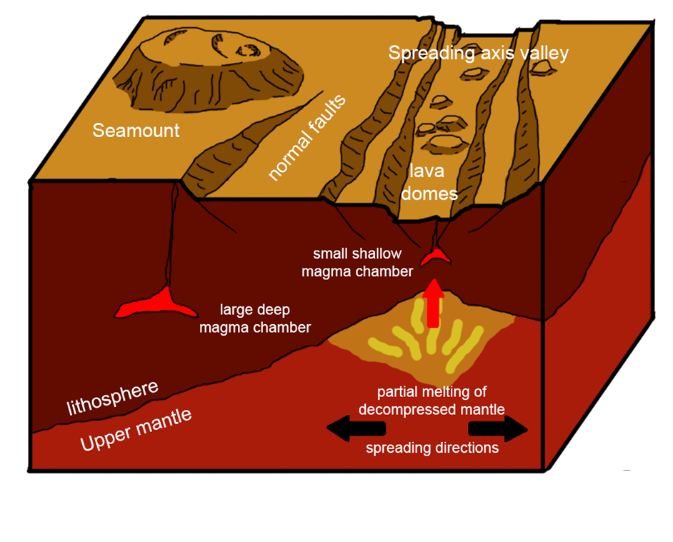
Our multibeam sonar mapping (see earlier post on swath bathymetry!) of the Costa Rica Rift has revealed a surface dotted with bulbous lava domes and giant seamounts. Both of these structures are formed from the same material, but differ greatly in proportions. So, what determines if a lava dome forms rather than a seamount?

At the rift axis where new seafloor is being generated the Earth's crust is thinner. Melt rising from the Earth's upper mantle will reach a depth of neutral buoyancy with the surrounding rock close to the seafloor. At this depth, melt builds up and eventually generates enough pressure to rise to the surface. Erupting slowly and in small volumes, the lava doesn't flow far from the eruption point, creating lava domes <200 m high and ~1000m wide.  
 
Schematic drawing of the Costa Rica Rift, showing seamounts, lava domes and their respective magma chambers
A few kilometres off axis, seamounts are observed, and their shape is in stark contrast to that of the lava domes. These volcanoes are much wider (4500m) than they are high (600m) with steep flanks and flat plateaus. This large flat top suggests lava flows spread far from the eruption site due to a high effusion rate. 

The crust further from the spreading axis is thicker, resulting in magma pooling in chambers at greater depth. To generate enough pressure to erupt, these magma chambers have to fill with larger volumes of melt then the ones on axis. At the point of eruption a fracture will open along a line of weakness, providing a conduit for the magma chamber to empty its melt. These larger magma chambers at greater pressure produce more effusive eruptions at higher volumes than those characteristic of forming lava domes.

The distribution of the lava domes and seamounts found on the seafloor around the Costa Rica ridge can inform us about the properties of the magma chambers at depth, eruption rates and pathways to the seabed.

Monday, 2 February 2015

Recovering OBSs


After deploying our grid of OBSs around the Costa Rica Rift, we have finished acquiring our seismic data in this area, and are halfway through recovering the instruments again.

An OBS instrument (ocean-bottom seismograph), showing the concrete anchor on the bottom and the yellow floats on top, with the white strayline strapped on.
Once on the seafloor, the OBSs remain attached to their anchors recording data until they receive a command to be released. Part of the instrument, called the ‘acoustic release’, has a unique code in the form of a series of pings at different frequencies. We send this signal out from the ship when we are near the position of the instrument we are recovering, triggering the acoustic release system to send a very high current through a ‘burn wire’, which will then burn through and release the OBS from its anchor. Yellow floats attached to the top render the OBS buoyant enough to float up to the surface, where its strayline is hooked and the instrument pulled aboard to have its precious data downloaded. 

A set of 16 acoustic releases ready to be dunked in the water for testing, to see if they are receiving the signals from the ship
We’ve also performed some initial processing of both multichannel reflection (from the hydrophone streamer) and the wide-angle OBS data, to check everything's working correctly and do some quality control.

An OBS ready to be deployed by moonlight. Each is fitted with a flag, light and radio to help spot the instrument once it reaches the surface
Wildlife update
We’ve been very lucky with wildlife already on this cruise, with another pod of dolphins spotted, along with a turtle and more flying fish and squid! The boobies that accompanied us on JC112 have also returned, and are sadly recommencing painting the forecastle deck white.