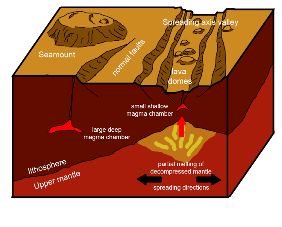
Our multibeam sonar mapping (see earlier post on swath
bathymetry!) of the Costa Rica Rift has revealed a surface dotted with bulbous
lava domes and giant seamounts. Both of these structures are formed from the
same material, but differ greatly in proportions. So, what determines if a lava
dome forms rather than a seamount?
At the rift axis where new seafloor is being generated the
Earth's crust is thinner. Melt rising from the Earth's upper mantle will reach
a depth of neutral buoyancy with the surrounding rock close to the seafloor. At
this depth, melt builds up and eventually generates enough pressure to rise to
the surface. Erupting slowly and in small volumes, the lava doesn't flow far
from the eruption point, creating lava domes <200 m high and ~1000m
wide.
 |
| Schematic drawing of the Costa Rica Rift, showing seamounts, lava domes and their respective magma chambers |
A few kilometres off axis, seamounts are observed, and their
shape is in stark contrast to that of the lava domes. These volcanoes are much
wider (4500m) than they are high (600m) with steep flanks and flat plateaus.
This large flat top suggests lava flows spread far from the eruption site due
to a high effusion rate.
The crust further from the spreading axis is thicker,
resulting in magma pooling in chambers at greater depth. To generate enough
pressure to erupt, these magma chambers have to fill with larger volumes of
melt then the ones on axis. At the point of eruption a fracture will open along
a line of weakness, providing a conduit for the magma chamber to empty its
melt. These larger magma chambers at greater pressure produce more effusive
eruptions at higher volumes than those characteristic of forming lava domes.
The distribution of the lava domes and seamounts found on the
seafloor around the Costa Rica ridge can inform us about the properties of the
magma chambers at depth, eruption rates and pathways to the seabed.
No comments:
Post a Comment
Thanks for your comment!